|
|
|
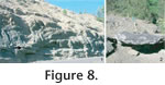
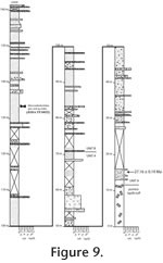
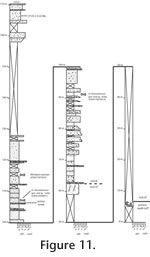
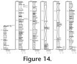
STRATIGRAPHY AND SEDIMENTOLOGYThe Cenozoic geology of south central Washington is heavily influenced by volcanism and tectonism from the Cascade volcanic arc, shown by andesitic and dacitic lava flows, pyroclastic flows, and igneous intrusions (Vance et al. 1987). Volcaniclastics and lava flows of the Ohanapecosh Formation extend from the Columbia River Gorge to Snoqualmie Pass, and represent early volcanism of the Cascade arc in south central Washington (Vance et al. 1987). Early work (Grant 1941) defined these strata as the lowest unit in the Keechelus series, which was later split into the Ohanapecosh Formation and the Fifes Peak Formation (see Waters 1961 for discussion). The Ohanapecosh Formation unconformably overlies Eocene quartzose sandstones, silicic volcaniclastic rocks, and subaerial basalt flows (Vance et al. 1987). The type locality of the Ohanapecosh Formation in Mount Rainier National Park comprises three major units: lava flows and interbedded mud flow tuffs; tuff-breccias; and debris-flow tuffs. It also includes minor accumulations of ash-flow tuffs (Fiske 1963). The Ohanapecosh Formation is over 1000 m thick, including near-source vent deposits (Fiske 1963; Fiske et al. 1963). Fiske et al. (1963) interpreted these as subaqueous deposits, citing normal grading and sheet-like deposition of the finer grained beds, splintering and shattering of the lavas, rare ripple marks, and channel crossbeds as evidence. Plant fossils preserved in equivalent-aged deposits west and south of the park indicate terrestrial input (Fiske 1963). In the Tieton River area, the Cenozoic strata lie unconformably upon the Tieton inlier, metasediments of Jurassic and Cretaceous age (Swanson 1964, 1978, Vance et al. 1987). The Spencer Creek sandstones and volcaniclastic rocks, Eocene in age, crop out along the southwestern margin of the Tieton inlier (Swanson 1964, 1978). The Wildcat Creek beds are over 300 m of volcaniclastic deposits exposed northeast of the inlier. The stratigraphic position, alteration, and normal grading common in the unit indicate that the Wildcat Creek beds are a distal volcaniclastic facies of the Ohanapecosh Formation (Swanson 1964, 1978). This study follows Swanson's (1964, 1978) informal designation of three distinct units. The lower Wildcat Creek beds consist of over 20 m of pedogenically altered tuffs cropping out near Milk Creek and along Wildcat Creek. One tooth, belonging to a rhinocerotid or hyracodontid (UCMP 65230), was collected previously near Milk Creek. The middle unit, informally called the pumice lapilli-tuff unit, is a 20 m thick lapilli-tuff with distinct blue-green pumice lapilli that produced no fossils. The upper Wildcat Creek beds are 260 m of altered volcaniclastic tuffs and lapillistones. Thirty-four fossil specimens of at least 14 taxa of terrestrial mammals have been recovered from this unit, which is the primary focus of this study. The Burnt Mountain Tuff of the Fifes Peak Formation unconformably overlies the Wildcat Creek beds and is distinguished by exhibiting relatively less alteration. Exposures of rocks similar to the Wildcat Creek beds crop out north of the study area, but are beyond the scope of this project. Lower Wildcat Creek Beds
The Milk Creek tuff is 15 m of pedogenically altered silts and clays. One soil profile, with five units, was measured. Unit one is 26 to 36 cm thick and consists of a slightly calcareous silty layer with mud-rich pebbles. Clay-rich coatings are common throughout this unit. The upper boundary is irregular and sharp with 2 to 3 cm of relief. Unit two is a silt-rich mudstone with medium to coarse subangular blocky ped structure, 16 to 35 cm thick. The exterior of peds is covered in argillans. The upper boundary is smooth and sharp. Unit three, about 30 cm thick, is a claystone-rich layer with medium-sized sand grains with platy to medium subangular blocky structure. The unit is weakly calcareous with abundant fine prominent mottles. The upper boundary is smooth and sharp. Unit four is about 40 cm thick and consists of silty claystone with medium subangular blocky structure. Prominent fine mottles discontinuously coat ped surfaces. The upper boundary is gradual and smooth, 5 to 10 cm in relief. Unit five is 31 cm thick and consists of silty claystone with medium subangular blocky to fine prismatic structure. Common medium mottling occurs throughout this unit. The upper boundary is smooth and sharp, and the overlying unit resembles unit one. The small amount of illuvial material in units one and two is suggestive of C and BC horizons, respectively. Units three and four are interpreted as Bt2 and Bt horizons, respectively, because of the abundant argillans, and Unit five is a Bw horizon. Bt horizons are characteristic of Argillisols (Mack et al. 1993). Along Wildcat Creek, the lower Wildcat Creek beds consist of 30 m of massive extremely fine to fine tuffs. The contacts below and above this unit are covered. Common slickensides, orange mottling, and low chroma color indicate that the lower Wildcat Creek beds are Gleysols or gleyed Protosols (Mack et al. 1993). Upper Wildcat Creek Beds
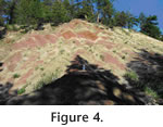
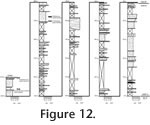
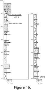
The thickness of the exposed upper Wildcat Creek beds increases from the southeast to the northwest, from 150 m at the Highway 12 locality to 260 m along Thunder Creek. The upper Wildcat Creek beds are separated into two main lithologic units, a lower unit A and unit B. Unit A is characterized by massive pale olive extremely fine to fine tuffs with crudely bedded pale olive to pale green coarse tuff intercalations.
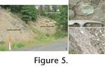
The lower 60 m of the upper Wildcat Creek beds comprise unit A, and are largely covered in vegetation except for drainages and roadcuts. A 1 m thick extremely fine tuff overlies the pumice lapilli tuff, with a sharp contact. Where exposed, coarse tuffs crop out as discontinuous ledges. A breccia couplet is best exposed in a roadcut along Highway 12, 40 m above the pumice lapilli-tuff, and exhibits no significant change in thickness. There is a sharp contact between a lapillistone ledge, representing the base of unit B and unit A.
The lower 60 m of the section, unit A, is covered with vegetation. The strata above the cover crop out on steep slopes and are coarse tuffs and 0.2 to 0.5 m thick lapillistone intercalations of unit B. The base of the exposure is a 1 m massive coarse tuff overlain by a lapillistone. This lapillistone is treated as the contact of units A and B, 60 m above the pumice lapilli tuff. Crude normal grading of ash matrix and mudstone clasts is common in the lower 40 m of unit B. The highest strata, 150 m above the pumice lapilli tuff, are exposed in the eastern part of this locality. Reverse grading and massive bedding are common in these upper strata, and they contain abundant, very coarse ash-sized, euhedral plagioclase phenocrysts, and pumice fragments. The highest exposed bed is a 0.1 m thick framework-supported breccia.
A prominent coarse tuff, 10 m thick, crops out on the ridge, and pinches out laterally. The tuff contains cross beds defined by normal grading. The uppermost 60 m of strata are extremely fine to fine tuffs with intercalated coarse tuffs and lapillistones. A coarse tuff with cross-stratification is preserved in the top meter of exposure. Thunder Creek-South Section. The complete sequence of the upper Wildcat Creek beds, from the pumice lapilli-tuff unit to the Fifes Peak Formation, crops out along Thunder Creek. Two sections describe the full sequence of the upper Wildcat Creek beds and the nature of the overlying contact.
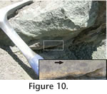
A 50 cm framework-supported breccia crops out intermittently along strike, 35 m above the pumice lapilli tuff. The overlying matrix-supported breccia is 1.5 m thick. A second framework-supported breccia is 1.5 m above the breccia couplet. Unit B is 235 m of fine to coarse tuffs with lapillistone intercalations. A dike intrusion, 11 m thick, cuts the strata along a North-South trend. The lower 120 m of unit B is largely covered, but four lapillistone to coarse-tuff graded beds were identified. A breccia, 108 above the base of unit 3, is supported by angular pebble lithic clasts.
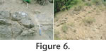
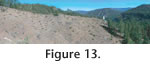
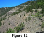
The upper 110 m are coarse tuffs with lapillistone intercalations. Mudclasts and pumice fragments are common. Mudcracks and crude cross stratification are present. The Burnt Mountain Tuff is covered, but the color change in detritus from olive to buff is inferred as the contact (Figure 15). The collection of Mesoreodon sp. (JODA NT06052N) and Promerycochoerus superbus (JODA TS070524), 45 m and 30 m below the Burnt Mountain Tuff, respectively, extends the highest stratigraphic occurrence of fossils in the Wildcat Creek beds.
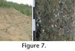
A prominent 10 m thick breccia, buff in color, at 100 m in the section, is the lowest occurrence of the Burnt Mountain Tuff. The breccia changes in thickness laterally and meter-scale relief below this breccia shows an unconformable relationship with the Wildcat Creek beds. Depositional EnvironmentThe Wildcat Creek beds were deposited as ash falls, ash flows, and debris flows. The lack of intercalated lava flows, finer grained volcaniclastics and thinner bedding than the Ohanapecosh Formation indicates they represent more distal volcaniclastic facies deposition, as suggested by Swanson (1964, 1978) and Vance et al. (1987). This conclusion is supported by abundant mudclast lapilli found in the upper Wildcat Creek beds. The lapilli are similar to the C-type accretionary lapilli, described and figured by Schumacker and Schminke (1991) that are found in volcanic deposits over 4 km from the source. The uniformly thick, clast-supported breccias are similar to hyper-concentrated flows with high sediment load described by Smith (1987). Debris flows are preserved as matrix-supported breccias with crude bedding, coarse normal grading, and poorly sorted gravel (Smith 1987). Unit B was deposited as air-fall deposits characterized by massive beds of extremely fine to fine ash, well sorted lapillistones, and crude normal grading.
The predominance of massive bedding and abundant euhedral phenocrysts indicate little to no reworking. Specimens JODA TF10032, JODA TS07055, and JODA NT06052N were preserved in massive extremely fine tuffs, suggesting preservation in ash falls. The disarticulated condition of the fossils and rodent gnawing, as seen on specimen UCMP 47165, indicates the bones were exposed prior to burial. The Argillisols of the lower Wildcat Creek beds and gleyed Protosols of the upper Wildcat Creek beds indicate moist conditions in well drained and poorly drained environments, respectively (Mack et al. 1993), although presence of mudcracks in these strata connotes intermittent drying. Moist conditions are supported by Goshen-type floras found in the Ohanapecosh Formation to the west, including plant taxa with large broad leaves and drip tips, typical of temperate riparian environments (Wolfe 1978; Retallack et al. 2004). The temperate climate shown in these deposits suggests a dryer climate than the tropical floras of the Chuckanut Formation, late Paleocene to Eocene in age, in western Washington (Mustoe 2002). This change is consistent with contemporaneous floral changes in Oregon (Retallack et al. 2004). The weakly developed paleosols of the upper Wildcat Creek beds suggest an unstable landscape characterized by rapid deposition, in contrast with slower rates implied by better soil formation of the lower Wildcat Creek beds (Mack et al. 1993). The well drained soils of the lower Wildcat Creek beds support the hypothesis of Vance et al. (1987) that the Tieton River area was a local topographic high prior to the deposition of the pumice lapilli tuff and upper Wildcat Creek beds. |
|