|
|
|
THE STRATIGRAPHIC DEBATEThe Inset Idea Proposed by WatersOn the Waters 4-Extension Profile (Figure 19), between horizontal datum 7.00 m and datum 7.75 m, a steeply inclined partial line marked with crosses is labeled as a "Disputed Contact." The upper half of this contact, the upper half-meter, is in modern soil, so the disputed portion is but 0.5 m thick. When this line is traced northward, it marks the base of a series of cross-bedded channel deposits that is about 2 m thick (preserved) at datum 11 m and datum 14 m. Using the nomenclature of Irwin-Williams, these channel deposits are designated Units B, C, D, and E, which include the layers that yielded bifacial artifacts. Waters identifies this contact as an unconformity and projects the contact upward through the disputed interval to the modern surface of the Tetela Peninsula some 10 m higher. In other words, he reconstructs an ancient stream channel 11 m deep, cut through the sediment stack containing the Buena Vista lapilli, the Tetela brown mud, and the Hueyatlaco ash, and of which only the lowest 2 m of sediment are preserved. A related idea proposed by Waters is that the thick section of clay south of the disputed contact, and under the Hueyatlaco ash, is a vertisol. Bates and Jackson (1980) define a vertisol as "... a soil order that contains at least 30% clay, usually smectite ... found in regions where soil moisture changes rapidly from wet to dry, and is characterized by pronounced changes in volume with changes in moisture, and by deep, wide cracks and high bulk density between the cracks when dry." Further, Waters questions the stratigraphic position of the unifacial artifacts assigned to Unit I (Payn, 2006, time ca 1:29-1:32, Waters interview). In particular, Waters has compiled a "statistical cross section" of the position of the artifacts based on notebooks kept by workers at the dig, presumably reviewed by Irwin-Williams. Our interpretation of Waters' "statistical cross section" is that he reassigned some artifacts that he thought were mistakenly logged in an older bed (Payn, personal commun., 2006.) Waters seems to have repositioned the artifacts into a higher unit, not Unit I. The Waters' concept of a younger stream channel inset, that is, cut down to its present level from somewhere above the Tetela brown mud unit and is now represented by 2 m of preserved sediment and 9 m of missing section is a "vacant hypothesis," in the sense that much of the evidence for its existence is assumed to have eroded away. The presumed unconformable relation of these deposits to topographically higher beds such as the Hueyatlaco ash and Tetela brown mud cannot be directly demonstrated. Where does this deep channel cross the Tetela Peninsula, given that the Tetela brown mud is continuously preserved on the peninsula above it, with no evidence of its being cut through by an ancient stream? (Figure 6 and Figure 9). The evidence that follows makes us question the presence of Waters' deep channel. The Levee Model
Waters did not ignore this lighter layer south of his unconformity. He attributed it to a "drying phenomenon," (Payn, 2006, time 1:22, Waters interview) which he suggests accounts for its lighter color. Our explanation for the lighter layer in Trench 4, and for the "sand grading laterally to clay," has nothing to do with drying, however. Rather, we conclude that this deposit can be understood as a culminating part of the channel, namely a consequence of the channel becoming filled with muddy water and overflowing. We interpret the "sand grading laterally to clay" to be a levee and its related flood plain.
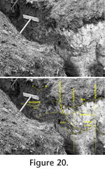
A consequence of this inferred process is that the sediment south of the channel is bedded, not a structureless vertisol as interpreted by Waters. The light colored diatomite layer visible in the Malde photo (Figure 20) immediately beneath the wooden brace in Trench 4 contains evidence of the bedding. Indeed, the diatomite layer becomes flatter to the south, just as our interpretation requires. Also, evidence of bedding to the south is visible in Fryxell's photo 106 (Figure 15), and Sheet 3 (Figure 17) of his profile shows many flat-lying beds. Diatoms vs. the Inset IdeaNumerous lines of diatom correlation contradict the proposed inset of Waters (VanLandingham, 2006, 2009a, 2009b, 2010a, and 2010b). Two sets of diatom samples link the deposits under the Hueyatlaco ash to the channel deposits of Waters' proposed inset (Figure 16). One set consists of VL2268 (monolith WSU73V15, Figure 17), VL2325, (a diatomite 1.5 m south of the disputed contact, Figure 20), and VL2324 in the channel just north of the disputed contact, Figure 20. The second set consists of VL2270 (just below VL2268), and VL2342 (just below VL2324). The above monoliths contain 209 diatom taxa. Many of the diatoms identified were extinct by the end of the Sangamon. Some of the extinct forms are not found in deposits older than the Sangoman, or older than Illinoian (VanLandingham, 2006). Extant taxa identified in the monolith first occurred in the Sangoman or the Ilinoian. Finding Sangamon diatoms and even older microflora has become the rule for Hueyatlaco (VanLandingham, 2004, 2006, 2008, 2009a, 2009b, 2010a, and 2010b). VanLandingham's unique diatom associations included a rare correlative link called the "Cocconeis-Navicula-Synedra generic dominance/subdominance association." Previously recognized only from the last interglacial in Poland, it occurs in six of VanLandingham's samples from the Hueyatlaco site: VL2268, VL2270, VL2272, and VL2325 (all beneath the Hueyatlaco ash); and VL2324 and VL2342 (both in the channel north of the disputed contact). VanLandingham (2009b) identified another unexpected correlation, a link between VL2270 (beneath the Hueyatlaco ash in monolith WSU73V15, Figure 16, Figure 17) and VL2342 (channel deposit north of the disputed contact, Figure 16). This correlation, represented by a Cocconeis-Navicula-Nitzchia-Synedra dominance/subdominance association, is known in the Western Hemisphere only at this site. Based on the stratigraphic positions of these diatom correlations, we conclude that all of them were deposited more or less late during filling of the channel, when the water overflowed to the south from time to time. Some of them are below the Hueyatlaco ash, in the interpreted flood plain deposits, and others are from the channel deposits that yielded bifacial artifacts. VanLandingham's correlations make the Waters idea of a much younger inset for the channel deposits untenable. Waters vs. Irwin-WilliamsAs noted above, Waters suggests that Irwin-Williams may have misplaced the unifacial artifacts in the stratigraphic section. While she did indeed change the nomenclature she used for the stratigraphy between 1964 and 1966 (Figure 4), she did not reassign the unifacial objects to a different layer from the one where they were originally described, suggesting that there was no ambiguity from which layer they came. She did not have doubts, however, about the assignment of the few unifacial objects to a particular layer, regardless of its name. She found and collected five artifacts in 1964, and two in 1966. For Irwin-Williams, conversion of the names was "simply a matter of terminological designation," as she pointed out in her open file 1966 progress report to the INAH. Our experience with the excavations with Irwin-Williams is that they were rigorously conducted and that Irwin-Williams herself insisted on removing any artifacts and recording their source (Irwin-Williams, 1967b). We find it improbable that the unifacial artifacts were somehow incorporated in Unit I when the overlying channel deposits were laid down, for example, by being intruded into the upper part of the layer. In particular, from the Irwin-Williams account of the intimate relation of Unit G and Unit I (Unit H was a local feature), and from her description of the channel deposits, the channel was not closely above Unit I from which she collected the artifacts. Furthermore, Irwin-Williams, in her open file1964 progress report to the INAH, described a "unifacial pointed piece" as being found "nearly touching" an elephant's hipbone. The entire assemblage was removed in a single block. Also, "A second unifacial pointed piece was recovered underneath a camel rib a short distance from the first." Such descriptions give confidence that the artifacts were found in place, not as intrusive objects (Irwin-Williams, 1964). |
|